Cooks Cove South has been used as a dump for rubbish and night soil in the past. Therefore, there is some contamination. Various people who either work for Bayside Council or have been elected to it cite contamination in Cooks Cove South as a reason to hand the park over for development. Dire scenarios of Council being bankrupted having to clean the site up are being presented.
Save Barton Park has invoked freedom of information legislation to obtain a number of reports from 2017 to see how bad the situation is. I am a member of Save Barton Park and so I also have copies. I have carefully studied the reports. The reports are written from the perspective of doing major works on the site, such as excavation for club house construction. If such works were to take place, contamination would definitely pose problems that the developer would have to overcome. But the reports neither state nor allow the inference that contamination at Cooks Cove South poses any health risk while the area is used as it is now. Here is a summary of various contaminants.
Main source for this section: "SURFACE WATER SAMPLING 2017 REPORT SOUTHERN PRECINCT COOK COVE DEVELOPMENT, ARNCLIFFE AND BANKSIA, NSW". The report identifier is "CES130608-BP-BE".
Firstly, all the really bad stuff such as lead and mercury is under the screening limits. What are the limits? Here is some text from the report:
Groundwater Investigation Levels (GILs) are adopted from the Australian Drinking Water Guidelines and ANZECC 2000 Guidelines for Marine Water Quality. The GILs are not acceptance criteria, the criteria are used to trigger further consideration of groundwater contamination, in the event that the GILs are exceeded.
Marine GILs were considered for this study rather than freshwater guidelines on the basis that the surface water in the wetlands is provided during high tides by a pipe from the Spring Street Drain and that water will drain directly to a marine environment (Cooks River).
What does that mean? Anything under the GIL does not place an obligation on Bayside Council to do anything about it. And even for substances that are over, it may not be so serious. Below is a summary, taken from the report, of what is over the limit.
Heavy metals concentrations in water samples were compared to the GIL applicable to marine waters. With regard the GILs, all concentrations were reported to be low or below the laboratory reporting limits with the exception of the following exceedances:
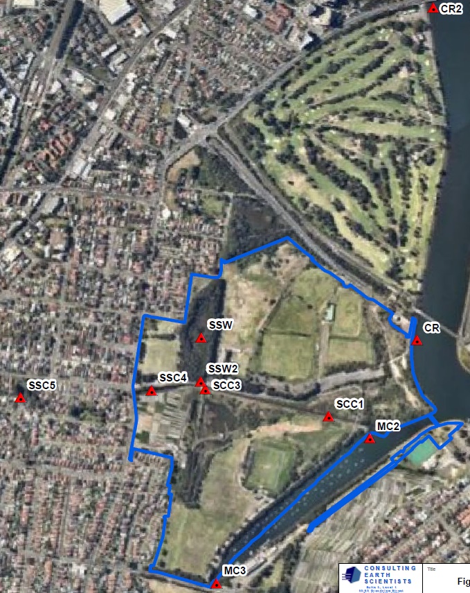
To make sense of the these exceedances, it critical to look at the sample locations. A screen shot of the sample locations is further down. Some sample sites are outside and upstream of Cooks Cove South. So any exceedances there are can't be blamed on Cooks Cove South and may even be the reason for exceedances inside Cooks Cove South. The report states something along those lines as well:
Elevated metal concentrations were detected in both up and down gradient locations, which is consistent with the results of the previous investigations in 2010, and indicates that it is likely the upgradient sources are contributing to the contaminant concentrations at the site surface water bodies.
What the results show is that for arsenic, boron and nickel, the exceedances are only at Spring Street Wetland. That means that all water flowing out of Cooks Cove South into the Cooks River is under the limit for these three substances. Spring Street Wetland is identified in the report as the location most affected by substances leaching out of the dump sites.
Manganese also exceeds the threshold at Spring Street Wetland, but not in Spring Street Canal, meaning the water flowing into the Cooks River is under the limit. However there is an even higher exceedance at location CR2, up the Cooks River from Cooks Cove South and therefore not caused by contamination at Cooks Cove South.
For Zinc, we have exceedances at location SSC5 which is well outside Cooks Cove South but from which water flows into Cooks Cove South through Spring Street Canal, reducing in concentration as it goes along, presumably because it is being diluted by water coming into the canal from other drains as well as tidal inflows. We also have an exceedance at location MC3 but that is where a storm water canal flows into Muddy Creek. We also have an exceedance at location CR2, well up-river from Cooks Cove South. We have no exceedance at Spring Street Wetland. It is therefore quite obvious that elevated Zinc levels are not caused by contamination at Cooks Cove South.
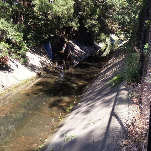
That leaves copper which has the highest exceedance at location SSC4 which is on Spring Street Canal, just inside Cooks Cove South. Copper contamination is lower at location SSC5, further upstream, and also lower at Spring Street Wetland, though above the threshold at one of the two Spring Street Wetland sampling locations. What is the explanation for the high levels at location SSC4? Obviously not Spring Street Wetland which has much lower levels. It is probably another drain that flows into canal. For example, there is a storm water drain which crosses Lynwen Crescent and joins Spring Street Canal downstream from location SSC5. See photo of the junction, taken from the footbridge at Lynwen Crescent Park. We can't even conclude that the exceedance at Spring Street Wetland comes from a source in Cooks Cove South. It seems entirely plausible that the exceedance is to blame on contaminated water flowing into Cooks Cove South, through location SSC4 and from there into Spring Street Wetland at high tide.
Comparing observed levels with investigation thresholds does not give us a good idea of how safe or unsafe the observed levels are. The toxicity of these substances has been studied to varying degrees. See comparisons below:
Arsenic is a toxin. Some countries have naturally high level of arsenic in ground water which is used for drinking water. So we have some pretty good data on the sort of levels which cause problems. The World Health Organisation recommends 10μg per litre as the upper limit for drinking water. However, about 19 Million people in Bangladesh have drinking water above the Bangladesh national standard of 50μg/L which is about the level at which start to we see statistically significant increases in health problems. Source: WHO Arsenic Factsheet. The American Agency for Toxic Substances and Disease Registry considers a long-term oral intake of 0.3μg/Kg/day (corresponding to 7L/day of Spring Street Wetland Water for a 70Kg person) to be of minimal risk. Source: ATSDR Arsenic Profile. So, the highest measured level at Spring Street Wetland at 3μg/L, though above the investigation threshold, does not seem to be a reason for alarm.
Boron is an important plant nutrient. Therefore, it occurs naturally in the human diet. Men consume on average 1.28mg (1280μg) per day. Studies on pregnant rabbits show no adverse affect on mother or fetus for boron dosages of up to 22mg per Kg of bodyweight per day. From that, the American Agency for Toxic Substances and Disease Registry derives a minimal risk level of 0.2mg/Kg/day (200μg/Kg/day) by dividing this level by a hundred (by 10 for interspecies variability and again by 10 for human variability). So, for a 70Kg person this would be 14000μ, compared with the highest level at Spring Street Wetland of 8200μg/L. Source: ATSDR Boron Profile.
Copper is a nutrient essential to human health. Recommended intake is 900μg per day for adult. Adults (in the USA) are estimated to consume from 1000μg to 1300μg per day. An intake of up to 0.1mg per Kg of bodyweight (or 7000μg for a 70Kg person) per day for up to 14 days poses minimal risk. By comparison, the highest measurement at Spring Street Wetland of 6μg/L. In Spring Street Canal, we have up to 56μg/L which is still a long way short of dangerous but which in any case is almost certainly from a source outside Cooks Cove South. Source: ATSDR Copper Profile.
Manganese is a nutrient essential to human health. Presumed adequate intake is 2.3mg per day. That is 2300μg, compared with 110μg per litre which was the highest level measure in Spring Street Wetland. Source: ATSDR Manganese Profile.
Nickel is a nutrient for various animal species but has not been clearly demonstrated to be a nutrient for people. American adults have a daily intake of Nickel in the range of 69μg to 162μg per day. The lowest dose that has been observed to cause adverse effects in animals is 1300μg per Kg of bodyweight per day (corresponding to 91000μg for a 70Kg adult). The highest measurement in Spring Street Wetland is 25μg/L. Source: ATSDR Nickel Profile.
Zinc is a nutrient essential to human health. Recommended intake is 11000μg for men per day. An intake of up to 0.3mg per Kg of bodyweight (or 21000μg for a 70Kg person) for up to 364 days poses minimal risk. Zinc levels are below investigation thresholds at all sample sites in Cooks Cove South except Spring Street Canal. The highes measurement in the canal within Cooks Cove South, which definitely flows into Cooks Cove South from the outside, is 16μg/L. Source: ATSDR Zinc Profile.
So, what would be the effect of metal contamination be if one were to go sight-seeing around Spring Street Wetland, trip, fall face-first into the water and swallow a mouthful or two? Nothing whatsoever. The investigation thresholds are extremely conservative, as they should be.
Perhaps most of the metals that can leach out have already leached out in the more than 40 years since landfilling ended in Cooks Cove South. There was only ever a finite amount there, and if they are leaching out, then they are diminishing.
What to do about Spring Street Wetland? Perhaps it is an option to simply leave it. Another option may be to modify the connection between Spring Street Wetland and Spring Street Canal to improve flushing of Spring Street Wetland. It should not make much difference to the rate at which contaminants leach into Spring Street Wetland. Therefore, it should not make much difference to the rate at which contaminants flow from Spring Street Wetland to Spring Street Canal.
Source for this section: "SURFACE WATER SAMPLING 2017 REPORT SOUTHERN PRECINCT COOK COVE DEVELOPMENT, ARNCLIFFE AND BANKSIA, NSW". The report identifier is "CES130608-BP-BE".
Heavy metals are not the only contamination. The report states:
The results of laboratory analysis indicated the shallow groundwater around the former landfilled areas was impacted by leachate. Contaminants in concentrations exceeding the groundwater assessment criteria included heavy metals, TPH and ammonia.
and
The results of analysis of the samples indicated that the Spring Street Wetland was impacted by landfill leachate with ammonia detected at a concentration of 74 mg/L. Heavy end TPH was also detected in the Spring Street Wetland samples.
The report does not go into any more detail about TPH (TPH stand for Total Petroleum Hydrocarbons). It has this to say about ammonia:
In addition, it was concluded in the 2010 report that the detected concentrations of ammonia migrating from the landfill into Muddy Creek and Cooks River were unlikely to pose a significant risk to the environmental condition of these water bodies.
Source for this section: "BASELINE LANDFILL GAS ASSESSMENT REPORT SOUTHERN PRECINCT, COOK COVE DEVELOPMENT, BANKSIA NSW". The report identifier is "CES130608-BP-BD". The report is from July 2017.
Firstly, the report goes into what needs to be done to solve problems that would be the result of the development. That is of no interest here as this site is dedicated to opposing the development of Cooks Cove South into a golf course. What is of interest is whether land fill gas seepage is a problem right now.
It is important to note that most of the landfill gas that was or will be generated is already gone. Here is the supporting text from the document (the text in the square brackets is also from the document).
Many literature sources indicate that a typical putrescible waste landfill passes through a number of well-defined maturation stages, followed by an exponential decay in methane generation rate, with little gas generation after periods of around 30 years, as shown in Figure 2 (see below). However, this assumes that favourable conditions exist for rapid anaerobic decay. In unfavourable conditions (e.g. dry fill, fully saturated fill, putrescible pockets in hard fill), degradation may be slow and methane generation time greatly extended, albeit at lower rates. [It is noted that the landfills in the Southern Area are typically favourable for rapid anaerobic decay, since the landfill is not capped and the tidal fluctuations and presence of leachate means that the waste materials are not permanently dry nor permanently saturated and the generated gases have been able to naturally vent to atmosphere vertically.]
The Australian Greenhouse Office (2008) estimated that 23% of degradable waste remains after 30 years and 11% after 50 years. [The landfills in the Southern Precinct have been complete for at least 40 years (landfilling ceased in approximately 1976) and as such, approximately 15% of degradable waste still may be present in the putrescible landfilled materials in the Northern Area.]
The report divides Cooks Cove South in four areas: C, D, D1 and E. Here is some of what it has to say about those areas:
Northern Area (Area C)
The results of surface and sub-surface gas monitoring indicate that the rate of landfill gas generation and gas flux through the landfill cover layer are low. Results further indicate that landfill gas is not accumulating under pressure in the waste mass.
Northern Area (Area E)
Although elevated gas concentrations were detected in the landfill waste mass, low flow rates were detected and the results of surface and sub-surface gas monitoring indicate that the rate of landfill gas generation and gas flux through the landfill cover layer are low. Results further indicate that landfill gas is not accumulating under pressure in the waste mass. As such, the previous assessment indicated that landfill gas management and mitigation was not required.
Southern Area (Area D)
The results of surface and sub-surface gas monitoring indicate that the rate of landfill gas generation and gas flux through the landfill cover layer was low. Results further indicate that landfill gas was not accumulating under pressure in the waste mass.
Southern Area (Area D1)
The results indicate that the ground gas regime beneath Area D1 (within the specific geological horizons monitored) is representative of a Characteristic Situation 2 (low risk). However, utilising the approach detailed in NSW EPA Guidelines (2012), as methane concentrations have been recorded above 20% in parts of the site, Characteristic Situation 3 (moderate risk) should be considered. This characteristic situation should only be considered for assessing the risks to proposed buildings within the Area D1 boundary. This currently comprises the proposed golf clubhouse and any ancillary buildings (such as maintenance sheds and golf shelters).
The description of area D1 is confusing. But the 20% methane concentration is obviously underground.
Of the four areas investigated, three pose minimal landfill gas risk in the context of the development. The fourth, D1, poses a moderate risk but only because of the proposed buildings including the clubhouse. There is no indication that any of the areas pose any danger or health risk while used as they are now.
Source for this section: "AREA D1 PRELIMINARY STAGE 2 ENVIRONMENTAL SITE ASSESSMENT AND AREA C GROUNDWATER MONITORING EVENT REPORT COOKS COVE, BESTIC STREET, BANKSIA, NSW", February 2016, report identifier is CES130608-BP-AJ.
Asbestos is not toxic in the usual sense, but the nature of asbestos fibres is such that inhalation of asbestos fibres injures lung cells and can cause fatal lung disease.
"Soil sampling" has been conducted at Cooks Cove in 2015 and Asbestos contamination as well as other contamination has been found. The quotes in "soil sampling" are deliberate. The cover soil over the landfill is typcially less than 20cm thick, as the report states:
Landfill cover soil was typically a silty sand topsoil, which was generally less than 0.2 m deep.
Five samples have been found to have Asbestos above investigation thresholds:
| Sample Identifier 1 | Sample Identifier 2 | Depth of sample (presumably in metres) | Date samples | Comment |
|---|---|---|---|---|
| 135893-45 | DIBH26 | 1.3-2.0 | 14/10/2015 | Chrysotile asbestos detected |
| 135893-50 | DIBH12 | 2.0-3.0 | 21/10/2015 | Chrysotile asbestos detected |
| 135893-51 | DIBH33 | 0.0-1.0 | 21/10/2015 | Chrysotile asbestos detected |
| 135894-9 | DIBH14 | 0.0-1.0 | 13/10/2015 | Chrysotile asbestos detected |
| 135894-28 | DIBH35 | 2.0-3.0 | 13/10/2015 | Chrysotile asbestos detected |
What does this all mean? The highest two soil samples are for the top metre at the sample site. Assuming cover soil of 20cm, this would suggest that those samples are 80% landfill. The three samples which are deeper completely consist of landfill. It is completely unsurprising that samples of landfill, especially old landfill, turn up materials such as asbestos. Is there enough asbestos up high enough to endanger people as they walk or run over the ground and thereby disturb the asbestos and cause it to become airborn and cause health problems? We can't tell from the report. That's not a defect in the report because the purpose of the report is to cover the implications of disturbing the site and not to describe how safe the site is when used as it is now.