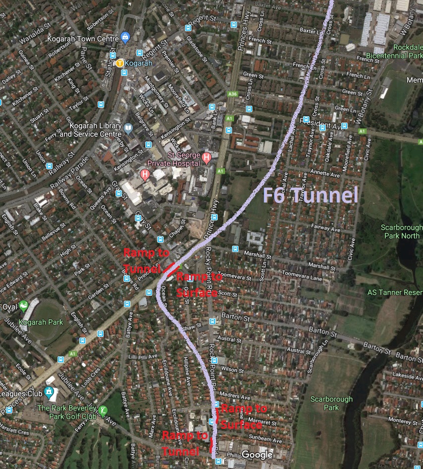
The biggest arterial road in the area is the Princes Highway. So the F6 should have an interchange with the Princes Highway. That interchange should be south of the intersection between the Princes Highway and Rocky Point Road to avoid a major choke point. There also needs to be an interchange with Rocky Point Road. Otherwise drivers using Rocky Point Road will cause chaos on the surface as they try to get to the Princes Highway interchange.
So, this is my idea: The F6 tunnel goes south from the New M5 towards Kogarah as per scoping report. But instead of curving east towards a President Avenue interchange, it keeps going to the Princes Highway and has an interchange there. This interchange would be south of the Princess Highway/Rocky Point Road intersection as the section between Rocky Point Road and President Avenue is a major choke point. The F6 then curves towards Rocky Point Road for another interchange and the end of stage 1. The F6 would be parallel and under the roads where it has interchanges with them. Therefore, the interchanges can be implemented as simple discreet ramps. It may even be possible to fit an interchange into Rocky Point Road, which has only four lanes, without significant road widening. Wherever there is a ramp, the surface road could be reduced to three lanes, one permanent in each direction and the third one tidal, meaning it changes direction so that the peak hour direction always has two lanes.
From the June 2018 Project Overview, it looks like the F6 would go under the Princes Highway not far south of Forest Road. There should be an interchange there also, again implemented as discreet ramps.
What about the traffic on The Grand Parade? From there, there would be no easy access to the F6. However a lot of traffic on the Grand Parade comes from Rocky Point Road via Sandringham Street. So traffic on The Grand Parade would be alleviated indirectly, especially once the F6 goes all the way to the Georges River.
What about the cost? It might not cost that much extra, and may well be cheaper in the long run, because the scoping report has the road going east, away from its ultimate destination and under the water table. The alternative which I am proposing avoids this detour. It also has simpler and presumably cheaper interchanges.
But in any case, we should build the F6 properly or not at all.